Category Archives: Watoosa

Animal Cruelty Laws in Georgia

If a pet wanders onto a neighbor’s property, is the neighbor justified to kill, trap, maim or otherwise injure the animal?

Ga. Code Ann., § 16-12-4, § 16-6-6

Title 16. Crimes and Offenses. Chapter 12. Offenses Against Public Health and Morals. Article 1. General Provisions.

§ 16-12-4. Cruelty to animals

(a) As used in this Code section, the term:

(1) “Animal” shall not include any fish nor shall such term include any pest that might be exterminated or removed from a business, residence, or other structure.

(2) “Malice” means:

(A) An actual intent, which may be shown by the circumstances connected to the act, to cause the particular harm produced without justification or excuse; or

(B) The wanton and willful doing of an act with an awareness of a plain and strong likelihood that a particular harm may result.

(b) A person commits the offense of cruelty to animals when he or she:

(1) Causes physical pain, suffering, or death to an animal by any unjustifiable act or omission; or

(2) Having intentionally exercised custody, control, possession, or ownership of an animal, fails to provide to such animal adequate food, water, sanitary conditions, or ventilation that is consistent with what a reasonable person of ordinary knowledge would believe is the normal requirement and feeding habit for such animal’s size, species, breed, age, and physical condition.

(c) Any person convicted of the offense of cruelty to animals shall be guilty of a misdemeanor; provided, however, that any person who has had a prior adjudication of guilt for the offense of cruelty to animals or aggravated cruelty to animals, or an adjudication of guilt for the commission of an offense under the laws of any other state, territory, possession, or dominion of the United States, or of any foreign nation recognized by the United States, which would constitute the offense of cruelty to animals or aggravated cruelty to animals if committed in this state, including an adjudication of a juvenile for the commission of an act, whether committed in this state or in any other state, territory, possession, or dominion of the United States, or any foreign nation recognized by the United States, which if committed by an adult would constitute the offense of cruelty to animals or aggravated cruelty to animals, upon the second or subsequent conviction of cruelty to animals shall be guilty of a misdemeanor of a high and aggravated nature.

(d) A person commits the offense of aggravated cruelty to animals when he or she:

(1) Maliciously causes the death of an animal;

(2) Maliciously causes physical harm to an animal by depriving it of a member of its body, by rendering a part of such animal’s body useless, or by seriously disfiguring such animal’s body or a member thereof;

(3) Maliciously tortures an animal by the infliction of or subjection to severe or prolonged physical pain;

(4) Maliciously administers poison to an animal, or exposes an animal to any poisonous substance, with the intent that the substance be taken or swallowed by the animal; or

(5) Having intentionally exercised custody, control, possession, or ownership of an animal, maliciously fails to provide to such animal adequate food, water, sanitary conditions, or ventilation that is consistent with what a reasonable person of ordinary knowledge would believe is the normal requirement and feeding habit for such animal’s size, species, breed, age, and physical condition to the extent that the death of such animal results or a member of its body is rendered useless or is seriously disfigured.

(e) Any person convicted of the offense of aggravated cruelty to animals shall be guilty of a felony and shall be punished by imprisonment for not less than one nor more than five years, a fine not to exceed $15,000.00, or both; provided, however, that any person who has had a prior adjudication of guilt for the offense of aggravated cruelty to animals, or an adjudication of guilt for the commission of an offense under the laws of any other state, territory, possession, or dominion of the United States, or of any foreign nation recognized by the United States, which would constitute the offense of aggravated cruelty to animals if committed in this state, including an adjudication of a juvenile for the commission of an act, whether committed in this state or in any other state, territory, possession, or dominion of the United States, or any foreign nation recognized by the United States, which if committed by an adult would constitute the offense of aggravated cruelty to animals, upon the second or subsequent conviction of aggravated cruelty to animals shall be punished by imprisonment for not less than one nor more than ten years, a fine not to exceed $100,000.00, or both.

(f) Before sentencing a defendant for any conviction under this Code section, the sentencing judge may require psychological evaluation of the offender and shall consider the entire criminal record of the offender.

(g) The provisions of this Code section shall not be construed as prohibiting conduct which is otherwise permitted under the laws of this state or of the United States, including, but not limited to, agricultural, animal husbandry, butchering, food processing, marketing, scientific research, training, medical, zoological, exhibition, competitive, hunting, trapping, fishing, wildlife management, or pest control practices or the authorized practice of veterinary medicine nor to limit in any way the authority or duty of the Department of Agriculture, Department of Natural Resources, any county board of health, any law enforcement officer, dog, animal, or rabies control officer, humane society, veterinarian, or private landowner protecting his or her property.

(h)(1) In addition to justification and excuse as provided in Article 2 of Chapter 3 of this title, a person shall be justified in injuring or killing an animal when and to the extent that he or she reasonably believes that such act is necessary to defend against an imminent threat of injury or damage to any person, other animal, or property.

(2) A person shall not be justified in injuring or killing an animal under the circumstances set forth in paragraph (1) of this subsection when:

(A) The person being threatened is attempting to commit, committing, or fleeing after the commission or attempted commission of a crime;

(B) The person or other animal being threatened is attempting to commit or committing a trespass or other tortious interference with property; or

(C) The animal being threatened is not lawfully on the property where the threat is occurring.

(3) The method used to injure or kill an animal under the circumstances set forth in paragraph (1) of this subsection shall be designed to be as humane as is possible under the circumstances. A person who humanely injures or kills an animal under the circumstances indicated in this subsection shall incur no civil liability or criminal responsibility for such injury or death.

Credits

Laws 1968, p. 1249, § 1; Laws 1992, p. 1654, § 1; Laws 2000, p. 754, § 12; Laws 2014, Act 588, § 1, eff. July 1, 2014.
Wildfire information and resources

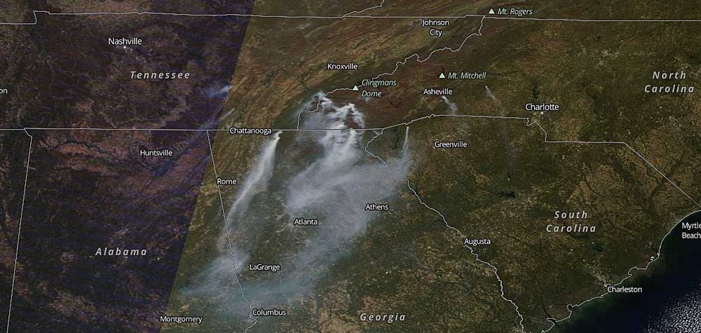
Wildfire information and warnings

ARCGIS Wildfire Maphttps://www.arcgis.com/home/webmap/viewer.html?webmap=df8bcc10430f48878b01c96e907a1fc3
(satellite early warning hotspots, fire area, and NWS warnings and real time weather station/wind direction)

Wildfires Near Me: https://wildfiresnearme.wfmrda.com/
( map/app with Twitter reports and managed incidents)

InciWeb: http://inciweb.nwcg.gov
(National Forest & multi-agency managed fire incidents)

North Carolina Joint Information Center (JIC): http://ncjic.blogspot.com
(public information office for the 2016 fires)

National Interagency Fire Center (NIFC): http://gacc.nifc.gov/

Southern Area Coordination Center (NIFC SACC)http://gacc.nifc.gov/sacc/

Wildfire Today:
http://wildfiretoday.com
(news and opinion from an NIFC & aviation veteran)


Recent Wildfires near East Chickamauga:

  • Long Hollow Rd (November)
    • small brush fire on both sides of the road
  • Chickamauga/Chattanooga NMP (November)
    • small grass fire
  • Strawberry Mtn (October-November)
    • medium wildfire

Zoning and traffic considerations for the Twin Cedars / Hwy 27 Intersection

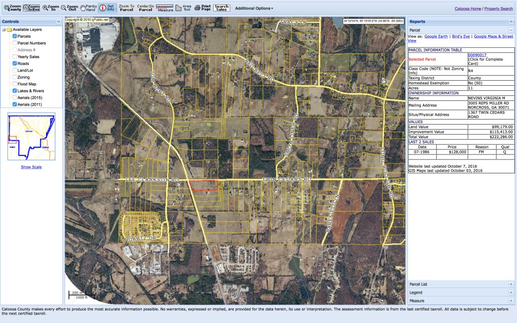
Catoosa County Planning Commission is considering a re-zoning and subdivision request for an 11 acre parcel on the southwest corner of Twin Cedars Rd and US Hwy 27. There is an additional plan for major reconstruction of the intersection, with turn lanes and traffic signals. None of this is favorable for local residents and property owners, nor is it necessary.

Zoning and Land Use of the Nevins parcel

County commercial land use and property zoning code is worded to favor promotion of intra-county commerce and residents’ convenience. There is no justification on those grounds for commercial development of the Nevins parcel. It is situated in an extreme corner of the county, with mainly agricultural and large residential parcels. Therefore, commercial development would not serve a large number of Catoosa residents.

Twin Cedars & US Hwy 27 area, showing the Nevins property

This corner of Catoosa can be thought of as “Watoosa,” because it is a remote corner of the county, surrounded and served by Walker County commercial and manufacturing zones.

Rock Spring, Ringgold, Chickamauga, Fort Oglethorpe and Lafayette are nearby towns that provide for any commercial need.

There are already multiple commercial and manufacturing zones serving the area (though most are in Walker): Fieldstone Farms has small retail, office and dining. Red Belt/27/Lafayette Rd is a large commercial zone with all commercial (retail, dining, lodging, office) and heavy manufacturing uses. Four Corners (Red Belt/Long Hollow/Burning Bush/Three Notch) has light manufacturing, multi-unit, and small retail.

Traffic Safety and Planning for Twin Cedars Rd and Lee Clarkson Rd at Hwy 27

The Twin Cedars and US Highway 27 intersection is dangerous. Relatively heavy and fast traffic on 27, with poor lines of sight due to hills, dips and turns, makes left turns and crossing from the secondary roads very dangerous. Numerous accidents and fatalities support the argument for traffic controls at the intersection.

The current, narrow rights of way on Twin Cedars and Lee Clarkson cannot handle tractor-trailers, and will not accommodate turn lanes. Common thought favors expensive and extensive intersection improvements that will require re-zoning, property condemnation, state and county right-of-way expansion and heavy construction. However, none of this is necessary, and there is an existing and reasonable alternative.

There is no need for a traffic signal at Twin Cedars/27. There is no need for turn lanes on Twin Cedars and Lee Clarkson. I use that intersection every weekday for my commutes, and nearly every weekend to visit Chickamauga. However, I never turn left, and I never directly cross 27.

The safest current method is to never turn left, and never directly cross 27 from Twin Cedars or Lee Clarkson. It is much safer to only turn right from Twin Cedars and Lee Clarkson. That may sound stupid and restrictive, but it makes sense if you use Farming Rock Rd to make left turns. Farming Rock has much better lines of sight on 27, and has much better ingress/egress for turns.

To turn left toward Rock Spring from Twin Cedars:

  • either Use Farming Rock and Lee Clarkson,
  • or Take Long Hollow and Kay Conley. Those routes may add one minute to the drive time, but they are far safer.

To cross 27 from Twin Cedars:

  • Turn right on 27, left on Farming Rock, right on Lee Clarkson.

To cross 27 from Lee Clarkson:

  • Turn left on Farming Rock, right on 27, left on Twin Cedars.

My suggestion for intersection improvement:

Add signage, striping and pavement arrows only.

  • Dangerous Intersection signs on Hwy 27
  • Right Turn Only on Twin Cedars
  • Right Turn Only on Lee Clarkson
  • Detour on Farming Rock Rd to Lee Clarkson Rd & vice-versa
  • Vehicle weight/axle restrictions (agricultural exception)

Why make Twin Cedars Rd and Lee Clarkson Rd “right turn only”?

This alternative would be a tiny fraction of the monetary and political costs of major construction for lanes and signals. It would solve the safety issues, and improve traffic flow. US Highway 27 traffic could still turn left, but Twin Cedars and Lee Clarkson should be made “right turn only” onto Hwy 27.

Image credit: qPublic.net

Georgia Power (Oglethorpe Power) and TVA eminent domain process

Property owners who have been approached by Tennessee Valley Authority (TVA), Georgia Power, North Georgia Electric Membership Corporation (NGEMC), Georgia Transmission Corporation, Oglethorpe Power Corporation or a government representative, and offered any amount for purchase of easement or real estate, have experienced the first step in a process which may end in exercise of eminent domain: the condemnation and compulsory forfeiture or sale of the easement or property.

Example: Church is offered $1.00 (one dollar) for a portion of church property, to build a transmission facility. Church members reject the offer. Power corporation counters with a more realistic monetary offer. The church again refuses. The property is condemned, seized and sold to the power corporation at “fair market value”. Real estate, appraisal or legal fees incurred by the church to affect or resist this process are not recoverable.

While the owners of property on which transmission facilities or lines would be located may receive “fair market value” for the use or loss of their property, nearby property owners will not receive compensation for effects of the project on their property value.

Judging by recent projects, TVA, Georgia Power or Oglethorpe Power eminent domain process will entail a few hours of public meetings, likely on a single day. This will be the primary forum for voicing concerns and objections to the proposed project and the eminent domain process.

How much is your property worth? If the Georgia Department of Transportation (DOT), TVA, NGEMC, Georgia Power, Oglethorpe Power, a city, a county, or the State decides to take your land in a condemnation process, you are entitled to just compensation. Just compensation is rarely achieved on the first offer from the condemning authority.

Landowner rights: If you are a landowner, if you own commercial, residential, or farm property that the DOT, Georgia Power, Oglethorpe Power, TVA, NGEMC or the government requires, speak to an attorney to protect your rights.

Condemnation proceedings: When your land or other real property is subject to a condemnation proceeding to make way for other uses (an interstate highway, a power line right-of-way, or other public uses), an attorney can help you determine an appropriate response.


Similar to the proposed Catoosa substation and transmission project, Georgia Power has a project in the Gainesville area, for which the right of eminent domain may be exercised.

Public meeting event information →

Georgia Power will hold public meetings, as required by O.C.G.A. 22-3-160.1, at the following times and place: Wednesday, September 24, 2014 from 2:00 PM to 4:00 PM and 6:00 PM to 7:30 PM Location: Brenau University Downtown Center 301 Main Street, SW Gainesville, Georgia, 30501

Read more: Georgia Press Association Public Notice Website (Archived) – Miscellaneous →


Pylon cable riggers dismantling reel” by User:Sandpiper – taken by contributor. Licensed under Public domain via Wikimedia Commons.

BILD law could limit local input

GA House Bill 176, titled “Mobile Broadband Infrastructure Leads to Development (BILD) Act limits the oversight that local governments and citizens exercise in the permitting process for cell towers.

This bill passed house and senate, and went to Governor Nathan Deal’s desk on March 24. The governor signed the bill April 21, so it is now Georgia state law.

111 (c) [& following...] A local governing authority's review of an application to modify or collocate wireless facilities on an existing wireless support structure shall not include an evaluation of the technical, business, or service characteristics of such proposed wireless facilities. A local governing authority shall not require an applicant to submit radio frequency analyses or any other documentation intended to demonstrate the proposed service characteristics of the proposed wireless facilities, to illustrate the need for such wireless facilities, or to justify the business decision to collocate such wireless facilities; provided, however, that the local governing authority may require the applicant to provide a letter from a radio frequency engineer certifying the applicant's proposed wireless facilities will not interfere with public safety emergency communications.

Without this oversight, citizens and local government could be unable to request:

  • the environmental effects of wireless microwave transmission
  • business justification for placement of wireless facilities, such as “to fill a dead zone in our coverage map”

Learn more about the bill

Cell tower would be a gigantic middle finger from Verizon to Georgians

See how laughable Verizon’s plans have been, since day 1.

“Can you hear me now? Can you hear me now? Can you hear me now? Good.” – Verizon Wireless commercial

My name is Chris Gilligan. I live with my wife, Michelle Zegarra, stepdaughter Salem, and Salem’s Grandmother Cindy, at 456 Watoosa Ridge in Catoosa County. Cindy was born a Napier, and has called Catoosa County home for most of her life.

Two weeks ago, we were all shocked to see a yellow Zoning Notice posted along our road easement, far away from public view. We called the number on the sign, and found that Rodney Richardson had applied for a permit to allow Verizon Wireless Partners of Tennessee to build a cell phone tower on his land.

A cell tower in the middle of a lake?

I went down to the Catoosa County Planning and Zoning Office last week, to have a look at the cell tower plans. When Faye Wood set out the file for me, I thought she had pulled the wrong folder. The site plan said “Blue Springs Lake”, but it listed my residential address underneath: 456 Watoosa Ridge.

While I pondered the thought of a cell tower in the middle of a lake, Faye poured me a cup of coffee and I sat down to take notes.

I learned that Verizon wants to drive up and down the private road that we have spent thousands of dollars and hundreds of hours maintaining. They planned a 100 foot by 100 foot razor wire perimeter around a communications tower site. Inside the wire, Verizon wanted to build an equipment structure with diesel generators, telecom equipment and heavy duty air conditioners. They would place a 180 foot tall tower on the site, plus a 9 foot extension, and they would have room to rent space on at least 2 additional arrays beneath their own antennas.

Verizon said they would plant some bushes around the security fence to prettify the site… but there’s no way those little bushes would hide what would be in plain sight from Chickamauga, Ringgold and Rock Spring.

Is there any way to prevent this from happening?

Shouldn’t there be a law against putting a cell tower in a residential area, surrounded by existing homes?

Guess what? There is a law: Catoosa County Code, Zoning Ordinance, Article IX, Section 9.3 is titled Communications Towers and Antenna. It regulates how and where cell towers can and cannot be built. I think the most important sentence in the article is contained in Section 9.3.8, paragraph 14. It states:

Necessity for residential location. An applicant for a permit for a location in a residential area must show that the proposed area cannot be adequately served by a facility placed in a nonresidential area. In addition to the foregoing, no tower or structure permitted under section 9.3 may be located within 1,000 feet of any existing residence.

NO tower or structure may be located within 1,000 feet of ANY existing residence. Verizon cannot build this tower within 1,000 feet of our homes. Regardless of whether it would be ugly – and it would be ugly – there would be health and safety risks inherent in having a cell tower so close to our homes.

Chris Napier’s home is within 1,000 feet. Jill and Dub Cofer’s home is within 1,000 feet. Lon and Carolyn Howard’s home is within 1,000 feet.

Cindy and Michelle and Salem’s and my home? It’s a little over 1,000 feet away from the proposed site… but it would have the most audible, visual and electromagnetic exposure, because it sits about 50 feet higher than the tower site.

Now, Verizon might try to argue that their tower would not be located in a residential district zone, so this objection based on proximity to nearby homes might not apply. But paragraph 14 does not mention the word, “district”. It says “in a residential area”. Mr Richardson’s property is classed as residential. Every neighboring parcel is classed as residential. The land lot contains a residential district, 1,500 feet from the tower site. Adjoining property in Walker County is a Residential district. I don’t think there’s any valid argument against this being a residential area.

Therefore, commissioners: as a resident and registered voter of Catoosa County, Georgia, residing at 456 Watoosa Ridge, I ask you to deny and reject this special use permit on the grounds that the tower and structures  within the proposed site would be within 1,000 feet of existing residences.

So, how did Verizon settle on this site?

If the site is called Blue Springs Lake, how did it end up on Watoosa Ridge?

Perhaps Verizon intended to build the tower at Blue Springs, but couldn’t find a willing property owner, until they located Mr Richardson, up against the county line.

I saw my childhood friend, Tripp Brown, in Ringgold the other day, and told him about this cell tower plan. Tripp comes from a family of builders and developers, and he said, “It’ll stick out like a sore thumb.”

Does anyone else think it’ll stick out like a sore thumb? I know I do, and I’ll bet plenty of other residents think it will, too. (Maybe during the hearing they will raise their hands, stick out their thumbs, and then turn those thumbs down to show their disapproval for this application.)

Verizon’s middle finger

Right now, Lookout Mountain is being forced to choose between a cell tower that looks like a giant pine tree, and a cell tower that looks like a giant flag pole. I’ve seen them disguised as giant palm trees and giant crosses, too. If Verizon forces us to live next to a 189 foot cell tower,  they might as well make it look like a giant middle finger, because that’s exactly what they are giving us.

We don’t want to live on Cell Tower Hill. We want to live on Watoosa Ridge… but it won’t be the same Ridge if there’s a big ugly antenna on top. Plenty of our neighbors and friends are with us in this fight, because Napier Ridge is the scenery they see when they step outside to take in the fresh air and the beautiful view. They are also with us because placing a tower in our neighborhood would be wrong, and it would violate a zoning ordinance that is meant to protect property values, cultural heritage, and public health.

“Blue Springs Lake Cell Tower”

Finally, I’d like to congratulate the genius who named this project. Now if a Verizon truck drives up and asks “where’s the cell tower site?”, we’ll just say, “Well… you go a couple miles on down the road… turn left, and then go jump in a lake.”


Image: Pogrebnoj-Alexandroff

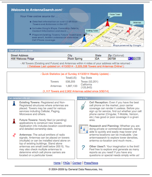
Cell tower distance to neighboring homes

Support for the objections to the proposed cell tower site.

According to approximate measurements using the online tools on the Catoosa County Parcel Maps website, the proposed tower site is less than 1,000 feet from existing residences.

Public Records Request: Results

I viewed the public records of the case file for #1140-14 this afternoon at the Catoosa County Planning and Zoning Office.

Please see Errata for edits, corrections and clarifications made to this site within 18 hours of viewing the public records.

Following is a transcription of my handwritten notes.


Site Plans

Verizon Wireless Tennessee Partnership, Lessee
575 Hickory Hills Blvd
Whites Creek, TN 37189
Kevin Caldwell, Construction Engineer
(615) 714-7114

Site: Blue Springs Lake, 456 Watoosa Ridge

Excell Communications, Inc
3608 7th Court South
Birmingham, AL 35222
Matt Russell
(205) 547-3578

Georgia Professional Engineer Stamped:
Clinton B Stewart
Pe 032944
3/12/14


Letter of Intent

3/17/2014

Chris Kinchen, Faulk & Foster
Agent for Verizon Wireless
(678) 437-6809 (cell)
chris.kinchen@faulkandfoster.com

Verizon Wireless is proposing to construct a 180′ + 9′ appurtenance monopole telecommunication facility at 456 Watoosa Rdg Rd, Rock Spring, GA 30739.

This site will be named Blue Springs Lake. The objective of this site is to provide an acceptable grade of service to Verizon customers in the local service area.

[…]

Unfortunately, in this situation, no existing structures currently exist within our search area which allow us to meet the required objectives.

[…]

The tower is designed to allow a minimum of 3 co-locators and their equipment.


Application for Special Use Permit

2/25/14

Certificate of Ownership
/s/Rodney H. Richardson
2098 Yates Springs
Ringgold GA 30736
(423) 693-4922

Authorized Agent
/s/Chris Kinchen
1774 Highland View Dr.
St Augustine, FL 32092
(678) 302-8770

Compliance and Authorization Letter

3/4/2014

/s/Peter Clement
Verizon Real Estate

Notarized Jean M Musa
(Mecklenburg County, NC)

for Verizon Wireless Site, Blue Springs Lake, Catoosa County, Georgia

Verizon Wireless authorizes Faulk and Foster and its employees and agents including Chris Kinchen, Zoning Specialist, to file applications and to arrange documentation necessary to obtain zoning and permitting application of the proposed project at this site.

Verizon Wireless also makes the following statements:

  • the proposed tower will accommodate collocated antennas for at least 2 comparable future users at a reasonable rate
  • Verizon Wireless will agree to remove tower and antenna within 180 days of cessation of use
  • there are no existing towers, structures or alternative technologies that can accommodate Verizon’s proposed antenna
  • there are no existing towers, structures or alternative technologies that meet Verizon’s engineering requirements, including, but not limited to height and structural strength that are located within the geographic area
  • there are no suitable existing towers, other structures or alternative technologies which could provide the services intended to be provided through use of Verizon’s proposed new tower
  • […] the proposed tower meets a currently identified need, and there are no additional locations planned to address the need in the event the proposed tower is erected. Once tower is erected, Verizon will continue to monitor it service and may propose future additions to its system in the are in the event it becomes necessary

(Untitled letter)

(undated)

Excell Communications, Inc.

To Whom It May Concern:

The closest collocation possibility is a Crown Castle tower located 1.95 miles away from the search ring center. This is too far away from the search ring center to meet Verizon’s coverage objectives.

Also, it only stands at a height of 200′, while Verizon’s RF engineers require a RAD of 250′. So, without adding additional height to existing structure, collocation would not be possible on this existing tower.

The second option is to go on an existing, 260′ Crown Castle tower that is located 2.38 miles away from the search ring center. While it does meet RAD requirements, it is too far away from search radius center to meet Verizon’s coverage objectives.

David W Walters Jr.
Site Acquisition / Collocation Specialist

Visual impact of cell towers

The visual impact of the cell tower would be severe.

Napier Ridge or Watoosa Ridge is  prominent , and can be seen from Chickmauga and Chattanooga National Military Park (the Battlefield), Chickamauga, Ringgold, Rock Spring, Lookout Mountain and Lafayette. A 189′ tower would be higher above the ridge line than the 150′ ridge is above the surrounding area.

There are currently no cell towers on the ridge; many local residents will prefer to keep the view they already enjoy.

Excellent cell coverage for the area is already provided by the 300′ tower (“big pine tree”) on the US 27 Bypass in Chickamauga, and rural towers in Noble and Rock Spring, Georgia.

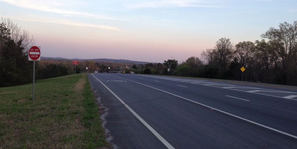
Hwy 27 Bypass at Osborn Rd in Chickamauga. Napier/Watoosa Ridge is directly ahead on the horizon (click to enlarge)

Below are photos of cell towers near the Walker county line in St Elmo (Hamilton County, TN). This ridge is similar in height to Watoosa/Napier Ridge.

Click below to enlarge and/or view full size images…